Hřebenová trasa Kammweg
Trasy • Pěší trasa • Střední náročnost
![]() |
Geising |
![]() |
0,0 km | |
délka etapy 24,5 km | ||||
![]() |
Holzhau |
![]() |
17,5 km | |
délka etapy 12,5 km | ||||
![]() |
Sayda |
![]() |
29,9 km | |
délka etapy 10 km | ||||
![]() |
Seiffen |
![]() |
38,4 km | |
délka etapy 11,5 km | ||||
![]() |
Olbernhau |
![]() |
46,9 km | |
délka etapy 21 km | ||||
![]() |
Kühnhaide |
![]() |
62,4 km | |
délka etapy 14 km | ||||
![]() |
Satzung |
![]() |
72,6 km | |
délka etapy 22,5 km | ||||
![]() |
Bärenstein |
![]() |
85,9 km | |
délka etapy 18 km | ||||
![]() |
Oberwiesenthal |
![]() |
100,0 km | |
délka etapy 18 km | ||||
![]() |
Breitenbrunn |
![]() |
116,2 km | |
délka etapy 14,5 km | ||||
![]() |
Johanngeorgenstadt |
![]() |
122,6 km | |
délka etapy 11 km | ||||
![]() |
Weitersglashütte |
![]() |
131,4 km | |
délka etapy 14 km | ||||
![]() |
Mühlleithen |
![]() |
142,9 km | |
délka etapy 15 km | ||||
![]() |
Schöneck |
![]() |
153,9 km | |
délka etapy 25 km | ||||
![]() |
Eichigt |
![]() |
171,1 km | |
délka etapy 21 km | ||||
![]() |
Burgstein |
![]() |
186,7 km | |
délka etapy 14,5 km | ||||
![]() |
Mödlareuth |
![]() |
198,6 km | |
délka etapy 21,5 km | ||||
![]() |
Blankenstein |
![]() |
212,9 km |
![](http://foto.turistika.cz/foto/13948/65874/th_18efe1_nemeckojerabinapomnicek008.jpg)
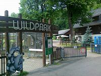
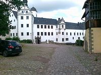
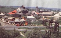
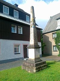
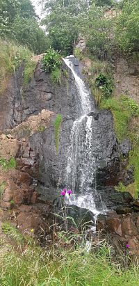
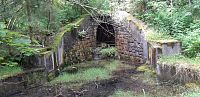
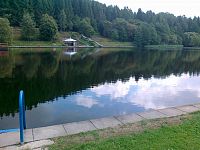
V květnu 2011 byla otevřena hřebenová trasa po německé straně Krušných hor, označená Kammweg. Vede z Geisingu do Blankensteinu. Je 289 km dlouhá a je rozdělená do 17 etap. Umožňuje jak toulání krušnohorskými lesy a loukami, tak i návštěvu památek, muzeí a přírodních zajímavostí. Přibližuje historii dolování a sklářství v Krušných horách. Trasa je značena modrým pruhem v bílém čtverci, nad pruhem je modrý nápis KAMM.
Mapky a popis tras jsou k dispozici v německých informačních centrech, nebo na www.kammweg.de
Geising
Příspěvky z okolí Hřebenová trasa Kammweg
![Poštovní milník v Geisingu](http://foto.turistika.cz/foto/13948/122686/th_59800ced27acd.jpg)
![hodnoceni 10/10](/nette/images/common/star/star-10.png)
![Geising Obec Geising](http://foto.turistika.cz/foto/13948/36092/th_8dbd0b_f_normalFile1-cinovec-026.jpg)
![hodnoceni 10/10](/nette/images/common/star/star-10.png)
![Smírčí kříž v Geisingu.](http://foto.turistika.cz/foto/13948/122616/th_5975b41c8bfc2.jpg)
![hodnoceni 10/10](/nette/images/common/star/star-10.png)
![ústí dědičné štoly Dědičná štola v Geisingu.](http://foto.turistika.cz/foto/13948/122654/th_59798d1ae05bd.jpg)
![hodnoceni 10/10](/nette/images/common/star/star-10.png)
![Vodopád Tiefenbach](http://foto.turistika.cz/foto/268638/136274/th_5f0abad70448d.jpg)
![hodnoceni 10/10](/nette/images/common/star/star-10.png)
![vodopád Vodopád na potoce Tiefenbach.](http://foto.turistika.cz/foto/13948/36076/th_b7f3f1_f_normalFile1-cinovec-020.jpg)
![hodnoceni 9/10](/nette/images/common/star/star-9.png)
![Štola u Geisingu](http://foto.turistika.cz/foto/268638/136262/th_20200710-103133.jpg)
![Koupaliště v Geisingu.](http://foto.turistika.cz/foto/13948/122634/th_21072017716.jpg)
![hodnoceni 10/10](/nette/images/common/star/star-10.png)
![Památník na Antona Gűnthera v Geisingu.](http://foto.turistika.cz/foto/13948/122601/th_5972f40c07e43.jpg)
![hodnoceni 10/10](/nette/images/common/star/star-10.png)
![muzeum Hornické muzeum Altenberg](http://foto.turistika.cz/foto/13948/36071/th_d59a9c_f_normalFile1-cinovec-015.jpg)
![hodnoceni 10/10](/nette/images/common/star/star-10.png)
![Saské 8000 – Scharspitze](http://foto.turistika.cz/foto/13948/136701/th_p-20200824-092346.jpg)
![hodnoceni 10/10](/nette/images/common/star/star-10.png)
![vodopád na potoce Tiefenbach Z Altenbergu přes hrad Lauenstein na Cínovec.](http://foto.turistika.cz/foto/13948/122688/th_598011c2ba2d0.jpg)
![hodnoceni 10/10](/nette/images/common/star/star-10.png)
![rozhledna Rozhledna Kohlhaukuppe](http://foto.turistika.cz/foto/13948/60938/th_d962e6_rozhledny-u-Cinovce-044.jpg)
![hodnoceni 9/10](/nette/images/common/star/star-9.png)
![Rozhledna Geisingberg Rozhledna Geisingberg](http://foto.turistika.cz/foto/13948/60948/th_56aa28_rozhledny-u-Cinovce-025.jpg)
![hodnoceni 10/10](/nette/images/common/star/star-10.png)
![Rozhledna Kohlhaukuppe (786 m./n.m.) Na skok do Německa 1. část - rozhledna Kohlhaukuppe (786 m./n.m.)](http://foto.turistika.cz/foto/130919/82795/th_16cfc9_dscn8345.jpg)
![Rozhledna Geisingberg. Na skok do Německa 2. část - rozhledna Geisingberg (824 m./n.m.)](http://foto.turistika.cz/foto/130919/83330/th_8c23ae_dscn8374.jpg)
![pinka Altenbergská pinka](http://foto.turistika.cz/foto/13948/36044/th_7b6776_f_normalFile1-cinovec-013.jpg)
![hodnoceni 7/10](/nette/images/common/star/star-7.png)
![hornická stezka Stará hornická stezka - 2.část](http://foto.turistika.cz/foto/13948/26302/th_f772e1_f_normalFile1-cinovec-044.jpg)
![hodnoceni 10/10](/nette/images/common/star/star-10.png)
![Fuchshΰbel Saské 8000 – Fuchshΰbel](http://foto.turistika.cz/foto/13948/136729/th_p-20200824-081754.jpg)
![hodnoceni 8/10](/nette/images/common/star/star-8.png)
![Krušnohorská obora.](http://foto.turistika.cz/foto/13948/122607/th_21072017705.jpg)
![hodnoceni 10/10](/nette/images/common/star/star-10.png)
![Poštovní milník v Altenbergu.](http://foto.turistika.cz/foto/13948/122411/th_595fba37ee704.jpg)
![hodnoceni 10/10](/nette/images/common/star/star-10.png)
![Poštovní kámen v Altenbergu.](http://foto.turistika.cz/foto/13948/122353/th_59576ad11efde.jpg)
![hodnoceni 10/10](/nette/images/common/star/star-10.png)
![rozhledna na vrchu Geising /832 m/ Altenberg](http://foto.turistika.cz/foto/13948/37237/th_a4fc4b_f_normalFile1-cinovec-012.jpg)
![hodnoceni 8/10](/nette/images/common/star/star-8.png)
![Saské 8000 – Biwak-Kuppe](http://foto.turistika.cz/foto/13948/136760/th_p-20200824-100649.jpg)
![hodnoceni 10/10](/nette/images/common/star/star-10.png)
![Hala Altenberg - občerstvení Lázně Altenberg](http://foto.turistika.cz/foto/35953/26610/th_74a92e_f_normalFile1-dsc00453.jpg)
![hodnoceni 8/10](/nette/images/common/star/star-8.png)
![Šibeniční rybník Šibeniční rybníky](http://foto.turistika.cz/foto/13948/36030/th_040aa8_f_normalFile1-cinovec-010.jpg)
![hodnoceni 10/10](/nette/images/common/star/star-10.png)
![Hrad Lauenstein.](http://foto.turistika.cz/foto/13948/122663/th_21072017697.jpg)
![hodnoceni 10/10](/nette/images/common/star/star-10.png)
![Cínovec](http://foto.turistika.cz/foto/0/2555/th_6948ec_7807.jpg)
![hodnoceni 6/10](/nette/images/common/star/star-6.png)
![1.Startujeme.. Přes hraniční přechod Cínovec na vyhlídku Kahleberg do Altenbergu](http://foto.turistika.cz/foto/43874/91528/th_001.startujeme....jpg)